Woodstock's 10 main areas, from Towne Lake to The Woodlands: ZIP codes, zoned schools and August 2026 Zillow home values, with a map.
Last checked Oct. 6, 2026. Sources: the City of Woodstock’s 2023 Comprehensive Plan (PDF) and its GIS map layers, the Cherokee County School District’s boundary maps, the state’s 2025 School Grades data, Zillow Research, the Census Bureau and OpenStreetMap. City Hall: 770-592-6000.
Woodstock is a city of 37,381 people in southern Cherokee County, according to the Census Bureau’s 2020-2024 American Community Survey five-year estimates. Its limits cover about 13.4 square miles on the city’s own GIS map, stretched east to west along Highway 92. I-575 runs north and south through the west side, with three Woodstock exits: 7 at Highway 92, 8 at Towne Lake Parkway and 9 at Ridgewalk Parkway. Main Street runs through downtown just east of the interstate.
Three things to know before you look at a listing:
- The interstate splits the ZIP codes. In our mapping of city buildings, 81% are in 30188, which covers downtown and everything east of I-575, and 19% in 30189, west of it. Many homes outside the city also have a Woodstock mailing address, so check a parcel on the county’s records.
- School zones do not follow city limits. The Cherokee County School District splits the city between two high schools: about 53% of buildings, from Towne Lake through downtown, map to Woodstock High and 47%, mostly east of downtown, to River Ridge High. Six elementary zones reach into the city. Always check one address with the district at 770-479-1871.
- The east is homes; the middle is shops. The city’s comprehensive plan says “large swaths of the city, especially in the east, are largely dedicated to residential uses,” and puts its highest-intensity Regional Activity Center along I-575 and Highway 92.
The areas at a glance
Home values are the Zillow Home Value Index for August 2026: a modeled typical value for the middle third of homes in the whole ZIP code, not a sale price. Zoned high school shares are of each area’s buildings, matched to the district’s boundary maps.
| Area | ZIP code | Zoned high school | ZIP home value, Aug. 2026 |
|---|---|---|---|
| Downtown | 30188 | Woodstock | $465,240 |
| South Main Street | 30188 | Woodstock | $465,240 |
| Towne Lake | 30189 | Woodstock | $449,993 |
| Highway 92 and I-575 | Mostly 30189 | Woodstock | $449,993 |
| Ridgewalk | Mostly 30188 | Woodstock | $465,240 |
| River Park and Brookshire | 30188 and 30189 | Woodstock | $465,240 and $449,993 |
| Arnold Mill Road and Woodstock Knoll | 30188 | River Ridge 63%, Woodstock 37% | $465,240 |
| Neese Road | 30188 | River Ridge 96% | $465,240 |
| Trickum Road | 30188 | River Ridge | $465,240 |
| The Woodlands | 30188 | River Ridge | $465,240 |
The citywide figure was $456,827, down 1.9% from August 2025. In ZIP 30188 the value fell 1.3% on the year and in 30189 2.5%. More in our home prices guide.
Map
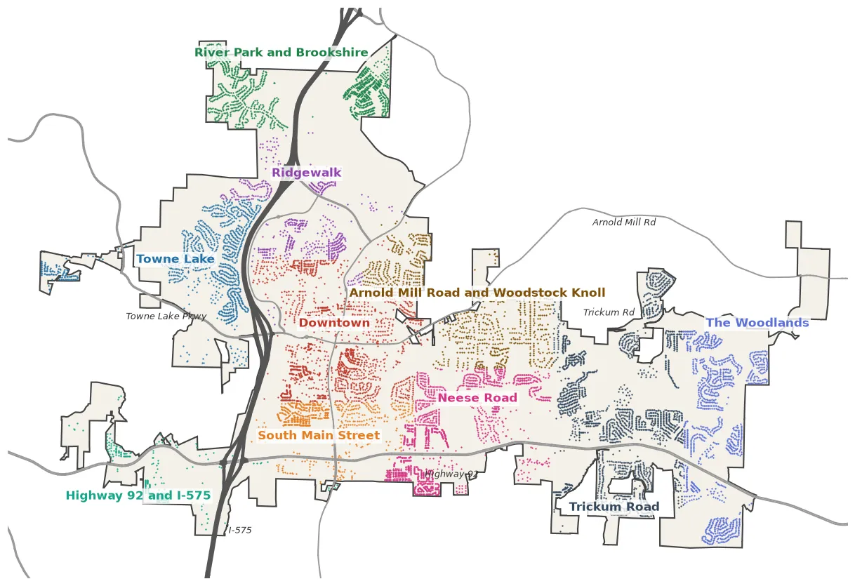
Map by Woodstock Post. Each dot is a building mapped in OpenStreetMap inside the city limits, colored by area. City limits are from the City of Woodstock’s GIS map service; roads and buildings are © OpenStreetMap contributors. Area edges are approximate.
West of I-575
Towne Lake. The city’s part of Towne Lake: Deer Run and other subdivisions off Towne Lake Parkway, with Woodstock Middle and Woodstock High on Towne Lake Hills South Drive. Mostly zoned for Carmel Elementary.
Highway 92 and I-575. A narrow strip along Highway 92 at Exit 7: the Target center, offices and five apartment and townhome communities.
The middle
Downtown. Main Street, City Hall’s park and the streets of homes, townhomes and apartments around them, all zoned for the Woodstock schools.
South Main Street. Subdivisions between downtown and Highway 92, and the shopping centers where Main Street meets the highway.
Ridgewalk. Newer apartments and townhomes around Ridgewalk Parkway, the Outlet Shoppes at Atlanta and Olde Rope Mill Park.
River Park and Brookshire. The city’s north end: Brookshire west of I-575 and the River Park subdivisions east of it.
East of downtown
Arnold Mill Road and Woodstock Knoll. Single-family subdivisions on both sides of Arnold Mill Road, where the school zones switch from Woodstock High to River Ridge High.
Neese Road. Subdivisions on both sides of Highway 92 around Neese Road, near Dupree Park.
Trickum Road. The area with the most homes, around the Walmart and Publix centers at Highway 92, with Little River Park under construction.
The Woodlands. The Woodlands, Mountain Brook and Vista Ridge subdivisions at the city’s east end.
Comparing Woodstock with its neighbors
Taxes, schools, home values and commutes for Woodstock and its three nearest city neighbors, side by side: Woodstock vs. Holly Springs vs. Kennesaw vs. Acworth. For every school, see our schools guide; for taxes, our property tax guide; for getting set up, moving here.
How we built this
We named only areas a public source places on a map. The sources were:
- The city’s GIS map layers. The City of Woodstock publishes its city limits, a Downtown District boundary, a subdivision map with 143 named developments and a shopping center map on its map service. Downtown and South Main Street are the Downtown District, split about a third of a mile north of Highway 92. Every other area is named for the main road or the subdivisions the city’s map names there.
- The city’s plan. The 2023 Comprehensive Plan divides the city into 10 character areas, from the Urban Core to Suburban Living. They describe what each area is like but are not named places, so we used them for the descriptions on each page, not the boundaries.
- Main roads. Area edges follow I-575, Highway 92, Arnold Mill Road and Trickum Road, from OpenStreetMap.
- Place names from OpenStreetMap, which names Woodstock Knoll and Deer Run at Towne Lake, © OpenStreetMap contributors.
- School zones from the countywide elementary, middle and high school boundary maps on the district’s maps page, which carry a 2019 file date, and its geographic assignment chart. The district says the school board approves boundaries each year, so the district is the authority for any address.
We found no homeowners association list published by the city, so these pages do not list HOAs. Area edges are approximate; the Cherokee County Tax Assessors’ records and the school district are the authority for any one address.
Frequently asked questions
What are the neighborhoods in Woodstock, Georgia?
Our guide covers 10 areas: Downtown, South Main Street, Towne Lake, Highway 92 and I-575, Ridgewalk, River Park and Brookshire, Arnold Mill Road and Woodstock Knoll, Neese Road, Trickum Road and The Woodlands. They follow the city’s Downtown District, its subdivision map and the main roads.
What ZIP codes are in Woodstock, Georgia?
Two: 30188 and 30189. In our mapping of city buildings, 81% are in 30188, which covers downtown and everything east of I-575, and 19% in 30189, west of the interstate.
What high school is Woodstock, Georgia zoned for?
Woodstock High or River Ridge High, depending on the address. In the Cherokee County School District’s boundary maps, about 53% of city buildings, from Towne Lake through downtown, are zoned for Woodstock High and 47%, mostly east of downtown, for River Ridge High.
Is Towne Lake in the city of Woodstock?
Partly. The city limits take in Towne Lake Parkway and neighborhoods such as Deer Run just west of I-575, but much of the wider Towne Lake area is unincorporated Cherokee County.
What is the typical home value in Woodstock, Georgia?
$456,827 citywide in August 2026, down 1.9% on the year, according to the Zillow Home Value Index. It was $465,240 in ZIP 30188 and $449,993 in ZIP 30189. The index is a modeled typical value, not a sale price.
Have your say